

WEEKLY WEATHER NEWSLETTER SUMMARY FOR THE STATE OF DELAWARE AND MID-ATLANTIC REGION
A weekly outlook of how things will be weather wise for the state of Delaware and other weather news.


This is a general GFS cycle of this week’s weather in the area. There doesn’t look like much except Monday and part of Tuesday. Just general rain and gloom before things relax as we get to the 4th of July holiday. I’m anticipating part of the 4th to rain in the morning, but be fine for the rest of the day and into the night. So, fireworks galore look good for most of the area.

“SHOULD I PUT ON THE AIR CONDITIONER IN JULY?”
The simple answer to this question is “OF course!” but if you look at the “Cooling Degree Day Anomalies” map there is a general belief that July will not be the hottest month this Summer. June wasn’t exactly scorching either. So, I believe we are probably due for a blistering heat wave of sorts soon we shall see if July brings the heat upon us. And it’s not exactly like July is going to save us money with energy costs. Gas is sky-high, so if we have a sizzling July we all may have to pay for it!
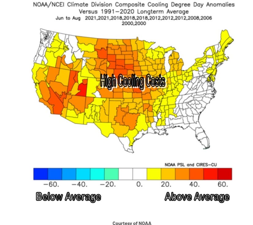
SOURCE: Weather Works
Well, if we are going to be talking about “Cooling” days we have to talk about the other side of the coin. “Heating Days” are shown in the table of 90+ days below to be above average for most of the area. These cities are all in the territory I have for general forecasting. The second column shows the average climatology for heating days above 90 degrees. The last column shows what is forecasted for the Summer.
So, Washington D.C. averages 40 days. They are set to have at least an average Summer to above average. The Philadelphia area is the closest to Wilmington, DE and within 70 miles of Dover so use Philadelphia’s days as a postmark. Philadelphia is a general heat island. It actually adds about a degree to cities within 20 miles of it further south. Wilmington is about 25 miles south of Philadelphia. So, if anything we do feel the heat of Philadelphia on any given Summer day/evening.

Source: Weather Works
GENERAL CLIMATE FACTS ABOUT DELAWARE:
Highest Temperature:
The highest temperature recorded in Delaware is 110°, Fahrenheit.
This record high was recorded on July 21, 1930, at Millsboro. Funny Stat!
This must be due to the fact that Millsboro is just inland of the coast and that it doesn’t get the benefit of sea breezes.
Lowest temperatures
The lowest temperature marked in Delaware, -17°, was recorded on January 17, 1893, also at Millsboro. Wow, I can’t explain this one except that must have been one MASSIVE cold snap that year.
The average monthly temperatures range from a high of 85.6 degrees ( Late Spring into the Summer months) to a low of 23.2 degrees (Winter Months)
Precipitation ranges from 45-50 inches of rain and less than 20 inches of snow per year. There have been years way above those averages but those are the norms. In a sense, it doesn’t really snow in Delaware. There are more days of frozen precipitation but in the form of freezing rain, ice pellets, or sleet than snow.
Last question sorry
My friend does them !! She close to campus. decentralized sports betting platform for crypto folks - https://tinyurl.com/3fbhv4ts