

The State of the Arctic Oscillation Causing the Cold and Snow in the East Over the Next Two Weeks

Okay, whenever I post these things it gets wildly misrepresented.
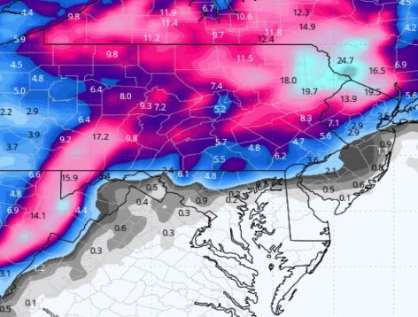
I'm showing a MODEL forecast for the next 10-12 days of POTENTIAL snowfall in the area. Why?
I'm just pretty impressed that this early the models are producing these projections because it tells me METEORLOGICALLY that PERHAPS, PV(Polar Vortex) is stretching towards the poles and some colder air is being released from Canada which will give us an early Winter surprise. This is the Arctic Oscillation, or AO. When it is in a negative phase then colder air is released from Canada.
So, in my due dilligence, I checked the NOAA website and I found this nice tidbit which, I guess, confirms my "intuition": "·
" In the Impacts section I discuss some impacts of polar vortex (PV) stretching and how it will impact the upcoming weather in the Northern Hemisphere (NH) but important changes are occurring in Siberia and the PV that could have long term impacts."
Things that make you go "MMMMMMMMMMMM" . :
}