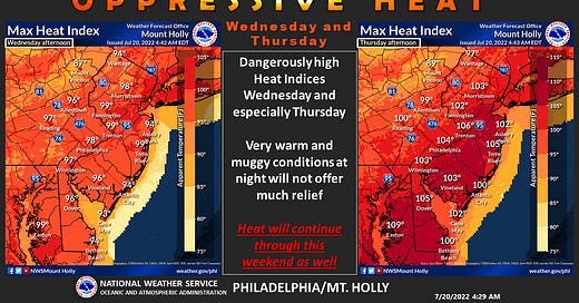
I think this says it all. This is how it will play out. We will get some periodic relief over the next 6-7 days, but it will be short-lived. A cold front will pull through Thursday night, but we won’t even know it passed. Friday morning might feel cooler than progressively as a Bermuda High offshore pumps WARM southwesterly winds right through the area. Saturday and Sunday will be oppressively hot. High temperatures will be in the mid to upper 90s with a heat index over 105 degrees F.
In terms of convection(storms), you might think with temperatures through the roof and all the elements present storms will be a given. This isn’t so certain. There will be some dry air around which will inhibit storm production. There is the possibility each day, but very scattered and if it does happen, it would offer almost no relief. So, if you are thinking we will get a storm to relieve the heat wave don’t bank on it.
At least we are not alone. Europe is burning! No, it’s just a really hot summer there.


